

Google reverse image search shows this as the original source: https://imgur.com/map-roads-of-canada-w7lDes8
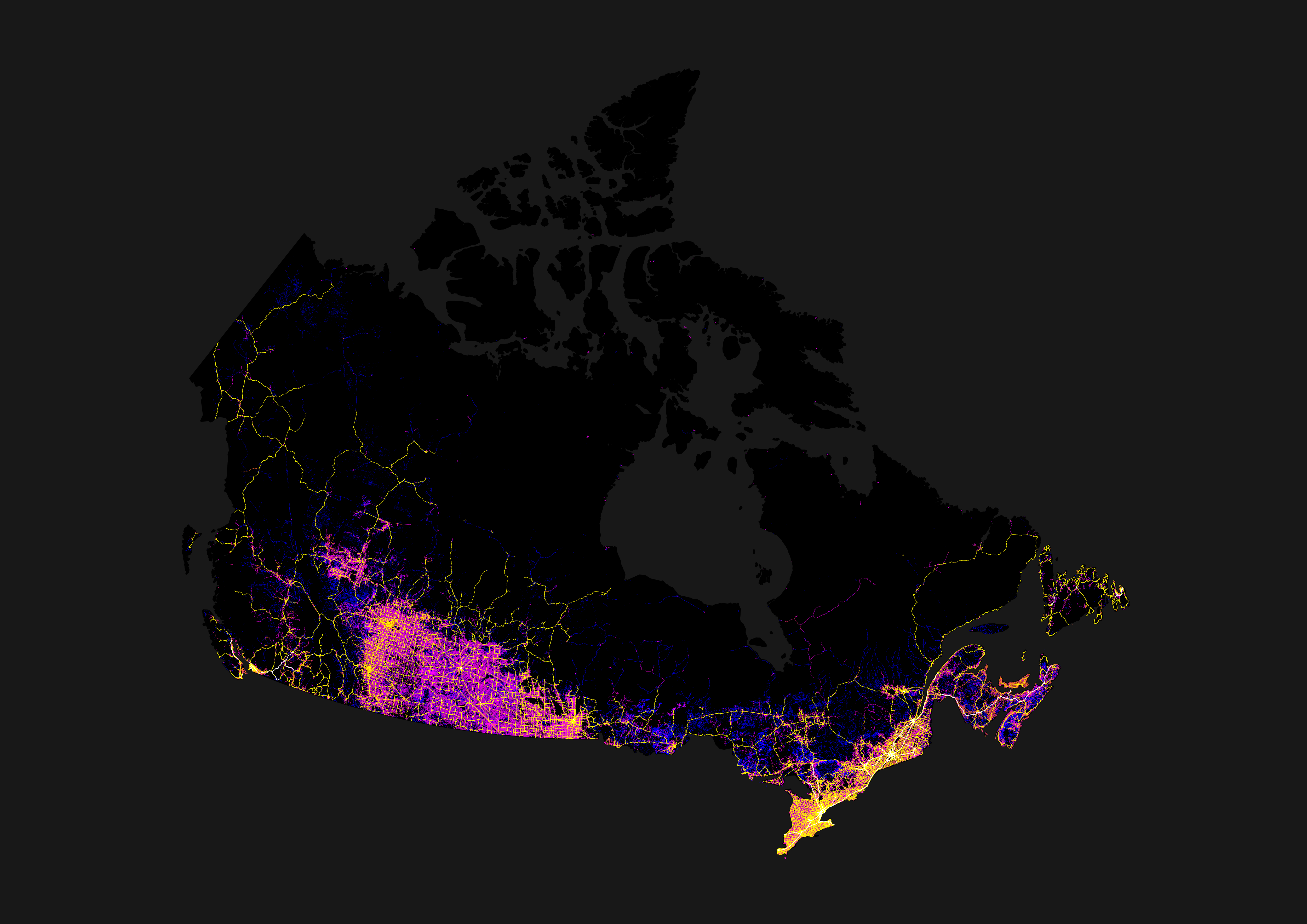
You can see the bit northeast of Thunder Bay where there is only one single major road connecting the entire East and the entire West.
Manitoba should invade down that highway – see how the rest of Canada feels when the Riel Rebellion …
Ah nevermind, let bygones be bygones.
Crazy how the whole northeast of Winnipeg is mostly dead.
I always found it funny driving through Thunder Bay to Winnipeg that it was called “northern Ontario” when you’re following the US border and landing squarely in southern Manitoba.
I don’t read this as Vancouver being isolated, I just read this as the prairies being victims/perpetrators of car dependent sprawl.
With a shit ton of complex geography, of course traffic is going to concentrate on a few main highways/roads
All of the agriculture and oil means there’s a road essentially on the whole survey grid too so that fills out a bunch of the map.
Totally. A bunch of roads all covering the farms. While in BC you won’t see “boat roads” for its huge water logistics.
The issue is mountains
The mountains keep Vancouver sprawl in check
They kind of don’t. The sprawl of the metro van region happens in Surrey, Langley etc.
Eh. I read it as BC not getting much funding for infrastructure from the feds, coupled with copious issues with development and treaties. BC’s population is overly concentrated in the GVRD, with almost half the provinces people living there. Part of the reason being the lack of infrastructure / job opportunities in other regions.
I celebrate all of those things. Hopefully we perform as few highway expansion projects as possible and focus on rail instead. Also hopefully BC’s population remain concentrated in metro Vancouver so we preserve as much wilderness as possible instead of sprawling endlessly.
It’s taken two decades just to get a highway expansion in Vancouver that serves millions of people.
There’s a bridge over a canal on one of the only ways to Vancouver from the rest of Canada and it’s pretty much falling apart, it’s embarrassing. It’s practically a farm bridge.
Tourists and visitors from out of province all have to cross that thing and it must be a hell of an introduction to Vancouver. It’s not even regular width for a two lane road, constant crashes in it. Good luck if two semi trucks need to cross side by side.
it pretty funny what people in Ontario call North. Even North Bay is actually in the southern half. Timmins too.
Its because farther north than that is barely inhabited. North of roughly the orillia line, geography and community size changes dramatically compared to what is south of orillia. Its a good seperatation for political purposes as the needs and cultures in these smaller communities are different from the southern communities.
Its a good seperatation for political purposes
Until the mid '90s, the map on the wall in the public area at Queens Park was cropped off just west of Sudbury.
Something my friends in Thunder Bay found indicitave of the level of attention and support they got from the provincial government
It would honestly be reasonable for northern and southern Ontario to decide on a line and be managed seperately, if not become their own provinces. The gta takes too much of the provincial focus sometimes. Just look at ford’s temper tantrum over torontos bike lanes, the province as a whole has much bigger issues he should be addressing.
Northern Ontario starts at the French River, Orillia is just where the shield starts when driving from Toronto. Its an important geographic change but Kingston is practically in the shield too and I would hardly call that Northern Ontario
The actual border, per government definition, is the southern edge of the Parry Sound district. Which is north of Orillia.
While technically true, that delineation has proven to be a political one. The previous liberal government redefined that district as southern Ontario, a move which was eventually reversed by the current PCs in part to afford the benefits of being a part of “Northern Ontario” to a PC stronghold that has been strongly contested by the greens in the past few elections. IMO theres more to it than just how the government defines it.
On the one hand, the government (specifically the MTO, the only ministry that cared at the time) has been using the “southern border of Parry Sound district” definition for at least 35 years. It was on the forms when I applied for my first driver’s license, if I recall correctly.
On the other hand, I don’t claim that “Parry Sound district” necessarily covers the same geographical location now that it did back then.
On the third hand, if I were drawing an “I think this is northern Ontario” line, it would be at about the latitude of North Bay, but that’s just my opinion and has no authority. At least the government definition is official.
On the fourth hand, I think I’ve visited the actual town of Parry Sound for all of one hour thirty-odd years ago, so I can’t speak to its demographics or culture. We’ve almost never had any reason to detour that far from the straight shot down to Toronto along Hwy. 11.
The North west is basically on fire year around now.
Blame the Ontario Mnistry of Transport. The official definition, such as it is, came from them.
I think this map + population density would make it very easy to spot where you can find oil in the world.
Low density + high amount of roads = oil
Or logging, or farming. There’s a bunch of reasons to have low population density road networks.
That correlates much more closely with agriculture than oil. Compare this map with one for arable land. Lots of the AB, SK, MB area covered in roads are also covered in farms, while large parts of that area does not have significant oil industry.
But wouldn’t farmed land increase if there is an abundance of oil? Needed for farming equipments.
I guess my point is. If there is an over abundance of oil it also facilitates agriculture because farming equiments is cheaper to power?
I don’t know if it translates to other places in the world because well…deserts and oceans but it would be interesting to find out.
But wouldn’t farmed land increase if there is an abundance of oil? Needed for farming equipments.
Actually, most of the ground would have originally been broken using literal horsepower, which runs on hay rather than oil. Tractors didn’t become the norm until after WWI (maybe not even until after WWII, I’m not an expert on agricultural history, but I do know that the reason you used to see wooden grain elevators every few kilometers along prairie railways was to accommodate farmers who were still hauling stuff in horse-drawn wagons). By the time the oil was being commercially exploited, most of the useful land was already under the plow.
This is pretty much the case. I farm in an area that was homesteaded late for most of the prairies (early 1900s), and that was all done with horses. I have an uncle that just recently passed away that was part of the transition to mechanical power, and their first tractor was gas-powered one since it would start in the cold. That would have been about WW2 time since he was a teenager when it showed up and they got rid of the draft horses.
Tractors didn’t become the norm until after WWI
And even during that transition, the first generation of tractors ran on wood or coal, not oil.
Interesting! Thank you for taking the time to explain
Canada’s shape looks kind of like a shark
Never realized Vancouver was that isolated.
It’s been a hot topic over the years just how screwed Vancouver would be in the event of a disaster. The amount of ways out of the Lower Mainland can be counted on one hand.
I mean, we were kind of cut off from the rest of Canada just few years back already, when the floods washed out all the highways leading out of lower mainland. Friend was telling me his parents had to drive over 16 hours through US to get back to northern part of Okanagan Valley.
Boats and trains. Fuck cars.
If you look closely at eastern PEI, you can see where the fields would be between the roads. Like it up with satellite imaging and you’ll see them there.
Saskatchewan, why are even your roads weird?
Which part? The southern prairie has ‘grid’ roads (magenta; literally roads in a grid, every mile E/W, every two N/S), with highways connecting the many towns and cities, settled because of agriculture. Then the northern shield (forest) has roads where they fit best to mainly indigenous communities.
with highways connecting the many towns and cities, settled because of agriculture.
And those towns were originally settled by farmers getting land adjacent to the railways, centered around the railway stations. They needed trains to get their produce to market, and to order their supplies from “the big city”.
Those early railroads had to build a water station about every 30 miles, as that was the distance the steam locomotives of the day could travel before needing to get more water. There were larger stations every 3rd or 4th water stop to re-supply with coal.
The history of the railroads is the history of Canada, especially so on the prairies.
If you look at Alberta and Manitoba, they also have the grid roads, but just looks more connected with a grid of highways following N/S or E/W. Saskatchewan’s highway system reminds me of nerve cells reaching out with all the angled highways spreading out from the cities.
I guess all the large areas shaded blue where I’m pretty sure there aren’t many roads (e.g. northern Ontario) are recent logging activity that still looks like roads to whatever software did the satellite image analysis.
Some of it’s actually rail and not roads—I’m pretty sure that one line running up to the bottom of James Bay is actually the Polar Bear Express’ tracks for at least part of its length. Some may also be clearance for seasonal (ice) roads, or high-tension power lines. And yeah, some of it’s probably logging.
Some of it’s actually rail and not roads
Such as the more northerly line running east from Winnipeg.


